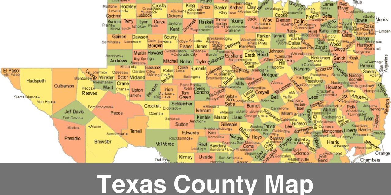
Texas is the second largest state in the United States and its renowned for its rich history, diversity, landscapes, etc. In this post, we’ll have a look at the map of Texas counties to understand the state’s organization and geography. If you are living or working in Texas or planning to visit Texas then here we have shared some of the important information that you must read. You can find printable Texas county map which is essential to understand the county wise geography of Texas.
How many Counties are there in Texas?
Texas has the highest number of Counties in any U.S. state, there are 254 counties in Texas which itself shows how vast the geography of Texas is.
Number of Counties: 254
If you are wondering what’s the point of dividing a state into multiple counties then please note that the county system ensures there is a proper local governance in place for the well being and rights of citizens. Texas is a big state in terms of population and size, different counties ensure law is followed and citizens rights are secured.
Each county has it’s own government structure i.e. there are judges, commissioners, and sheriffs managing local matters.
Following are some of the most popular counties in Texas:
- Harris County: It’s the most populous county in Texas, The county seat of Harris County is Houston.
- Dallas County: The county seat of Dallas County is Dallas which is a major center for business, culture, and entertainment.
- Tarrant County: The county seat of Tarrant County is Fort Worth. Known for its cowboy culture and world-class museums.
- Travis County: The county seat of Travis County is Austin. Known for it’s vibrant music scene, in fact Austin the “Live Music Capital of the World”.
- Bexar County: The county seat of Bexar County is San Antonio which is home to iconic landmarks like the Alamo and the River Walk.
- Collin County: The county seat of Collin County is McKinney. It’s a hub for professionals.
- Williamson County: The county seat of Williamson County is Georgetown. Known for its parks, historic downtown Georgetown, and strong economy.
- El Paso County: The county seat of El Paso County is El Paso.
- Montgomery County: The county seat of Montgomery County is Conroe.
- Galveston County: The county seat of Galveston County is Galveston. It attracts a lot of tourist from all over the world.
Each county has it’s own history and significance. To understand the geography positioning of Texas counties, you must have a look at the printable texas map with cities and counties.
Texas county map with cities
Houston is the largest city in Texas and the fourth largest in the United States. Each city in Texas has it’s own significance and history. For instance, Dallas is a major center for commerce and culture while Austin is labeled as the Live Music Capital of the World due to it’s vibrant music scene. There are different cities in each county, you need to check out the Texas county map with cities for more geographical understanding.
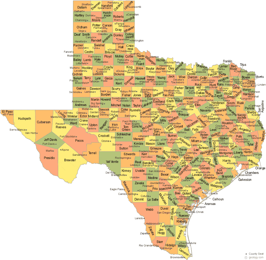
Map Source: https://geology.com/
More U.S, County Maps
Texas county map with rivers
Rivers play a huge role when it comes to agriculture and water supply. A good water supply is the necessity of every city or state. There are many rivers in Texas which are main source of water supply for human life, wild life, and agriculture. Following are the some of the major rivers in Texas:
- Rio Grande: It’s the longest river in Texas. Rio Grande flows through many counties such as El Paso, Presidio, and Cameron.
- Red River: This river flows through the northeastern counties, it marks part of the boundary between Texas and Oklahoma.
- Brazos River: This river is the major source of water for agricultural use and municipal use in the central counties of Texas. Brazos River is one of the longest rivers within Texas.
- Colorado River: This river is a major source of water supply to Austin and surrounding areas. It flows through the Travis County.
- Sabine River: This river flows through many of the eastern counties in Texas.
Different Regions in Texas
Through a county map of Texas, you get to know the geographical diversity the state actually has. You find everything here from plains and deserts to forests and coastlines. Texas is divided into five regions i.e.
- West Texas
- Central Texas
- East Texas
- South Texas
- Gulf Coast
Each region has it’s unique significance and history.
On this page, we’ve provided the Texas county map which is one of the most valuable tools when it comes to navigating through different counties, understand the geography of counties, and understand regional demographics, etc. A county map is often used by residents, travellers, and businesses for their purposes. If you living, working, or planning to visit Texas then make sure to have a county map with you for studying geography, or analyzing economic dats, etc.

