

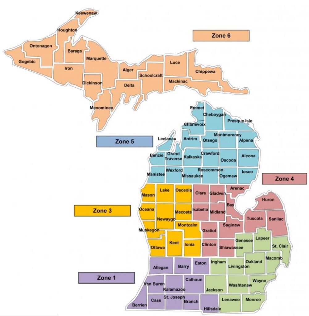
Michigan is a state in the United States and it’s situated in the Upper Midwest region. To understand the geography of Michigan, you must understand that Michigan is divided between two peninsulas i.e. Lower Peninsula and Upper Peninsula (U.P.). The majority of the state land area is comprised by the Lower Peninsula. In Michigan, there are a total of 83 counties and each county has its own character, significance, and history.
In this post, we’re covering the geography of Michigan with the help of Michigan County Map. The county map comes in handy when it comes to know the names of each county, see their boundaries and borders. There is so much to understand or explore when it comes to the geography of Michigan. Let’s get started to understand more about Michigan counties, cities, rivers, etc.
How many Counties are there in Michigan?
There are 83 counties in the Michigan. As mentioned earlier, Michigan is divided into two peninsulas i.e. Lower Peninsula and Upper Peninsula (U.P.). These two peninsulas are separated by the Straits of Mackinac. Michigan shares it’s border with other U.S states, a Canadian province, and four of the Great Lakes.
- Michigan has it’s border with three U.S. states Ohio, Indiana, and Wisconsin.
- Shares an international water border with Ontario, Canada.
- Michigan is also known for its lakes because it’s connected with four of the Great Lakes i.e. Lake Superior, Lake Michigan, Lake Huron, and Lake Erie.
Michigan is one of the most unique state’s in the United States due to its urban connectivity, connection with great lakes, and international relationships.
What’s the largest and smallest county in Michigan by area?
- In terms of area, Keweenaw County is the largest one in Michigan. It’s situated in the Upper Peninsula with a total area of 5,966 square miles. It is important to note that most of this area is in water only.
- Benzie County is the smallest county in terms of area, it’s located in the Lower Peninsula with an area of square miles.
- In terms of population, Wayne County is the most populous county in Michigan’s
If you want to know more about the counties in Michigan then you need to check out the printable Michigan county map.
Printable Map of Michigan with Counties
Michigan is home to 83 counties, each county is unique and has it’s own significance. If you are interested to study more about the Michigan counties, known their names, check out their border or boundaries, then you must check out the printable county map below. This map is best suited to be used for education or research purposes. Print a map today and use it wisely.
More U.S, County Maps
- Map of Georgia with Counties
- Map of California Counties
- Ohio County Map
- Texas County Map
- Florida County Map
- New York County Map
- North Carolina County Map
Michigan: The State of Great Lakes & Rivers
The geography of Michigan is incomplete if we don’t talk about lakes and rivers. The state of Michigan is bordered by four of the great lakes i.e. Lake Superior, Lake Michigan, Lake Huron, and Lake Erie. Apart from the lakes, there are many rivers which shapes the geography of Michigan.
Following are some of the major rivers in Michigan:
Grand River
Grand River is the longest river in the Michigan’s, it flows through the counties like Kent (Grand Rapids) and Ingham (Lansing). There are many fishing points, kayaking, and waterfront parks which are situated on this river.
Detroit River
Detroit River flows through the Wayne County and Canada. Belle Isle Park is one of the famous urban oasis that is located in the Detroit River.
Au Sable River
It’s one of the cleanest river, known for its excellent trout fishing. Au Sable River flows through counties like Iosco and Oscoda. It’s one of the favourite rivers among nature enthusiasts.
Water is an essential resource, we cannot survive without water. Rivers are a major source for drinking water, agriculture, irrigation, energy generation, etc. We often don’t know more or we don’t study more about the rivers, in fact, we should know our natural resources and make efforts to protect them. Check out the printable rivers map of Michigan below.
Who can use Michigan County Map?
A county map can be used by people of different age groups and from different industries. It can be used by students, travellers, researchers, etc. Understand the diversity of Michigan by using a county map. Here is who can use it:
Tourists can use this map
Planning to travel Michigan or go on a Michigan road trip them make sure to have Michigan county map with you and navigate easily. Through a map, you get to know the famous spots, view points, etc.
Do Research using a map
These days, many businesses and companies done their research using a map. Understanding demographics of a particular region or area becomes easier once you have a map with you.
Conclusion
Michigan’s county map is essential for navigating the state, whether for travel, business, or research purposes. With 83 counties offering diverse geography, culture, and economies, using a map helps you better understand and navigate Michigan.
