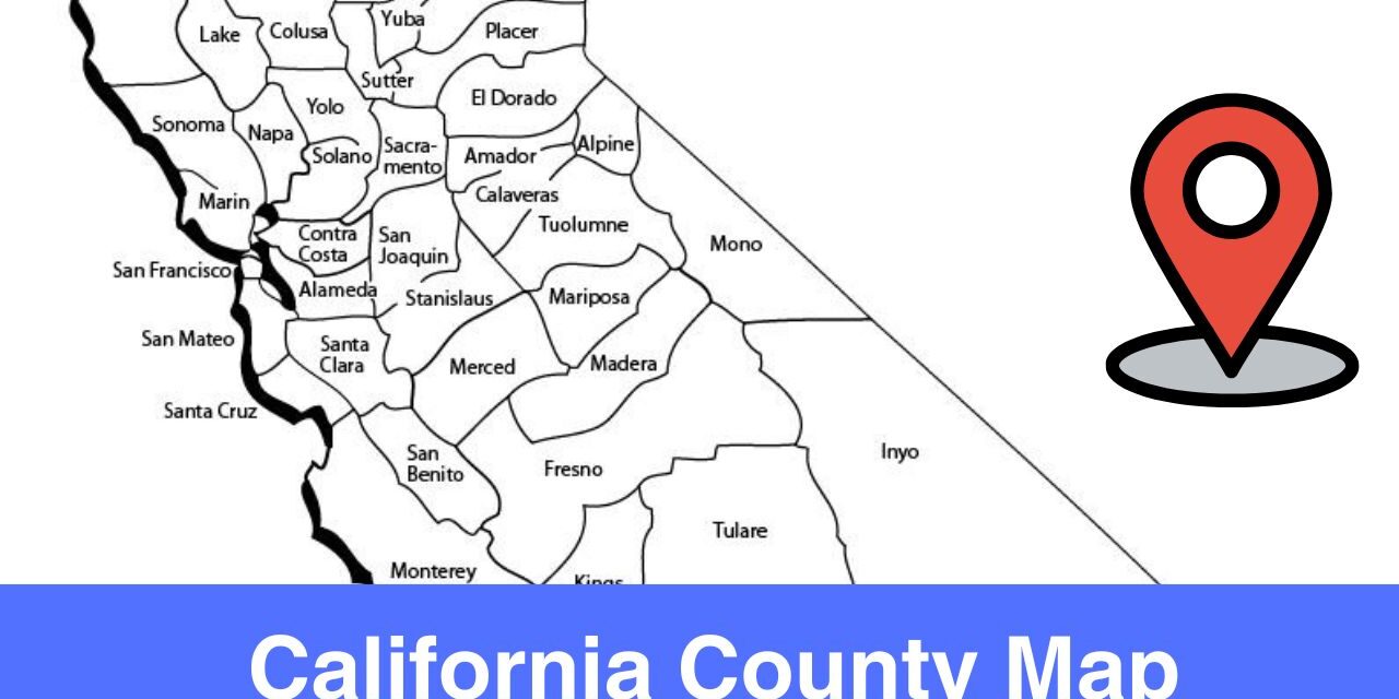
California is one of the most famous states in the United States, it’s most populous state. California has an impact on the nation in terms of economy, education, demographic, and culture. California is a land of diverse landscapes, you can find rainy northern coast here, Colorado Desert in the south, volcanic plateau, etc. In order to study the diverse geography and cultural diversity of California, you need California County Map.
The state of California is divided into different counties, each county has it’s local governance in place which takes care of local matters. The county wise distribution of state contributes to the well being of each individual. The major cities in California includes, Los Angeles, San Francisco, and San Diego.
What is the number of Counties in California?
In California, there are 58 counties. Each county has it’s own history, significance, and culture. The diversity among counties is what makes California great. It is important to have different counties in a state in order to have good governance and development.
Number of Counties in California are 58
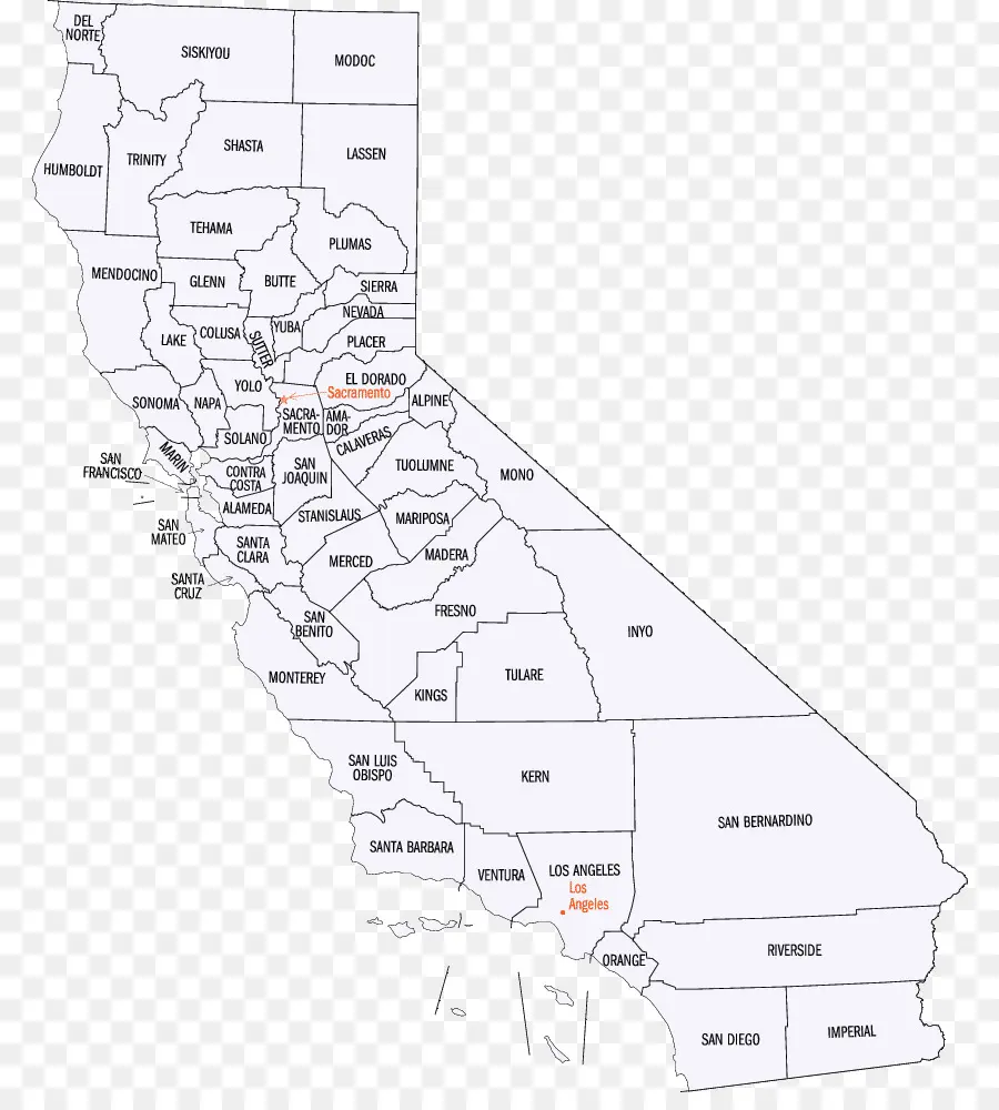
If you are interested to understand the geographic structure and borders of each county or simply want to know the name of each county in California then do check out the Map of California Counties shared in this page.
Here are some interesting facts about the Counties in California:
- San Bernardino County is the largest county in California in terms of area.
- San Francisco County is the smallest county by area.
- Los Angeles County is one of the famous county in California. It’s an entertainment hub. Over 10 million residents are there in this county which makes it the most populous county in California.
Understanding Geographic Diversity of California
The geography of California is breakdown into Northern California and Southern California for an easy understanding.
Out of 58 counties, 48 counties are in the Northern California and the 10 counties are in Southern California.
Northern California
Northern California is a region that covers the northern portion of the U.S. state of California. 48 counties are there in this region. Following are some of the most known areas in Northern California:
- San Francisco Bay Area
- Greater Sacramento area
- Metropolitan Fresno area
In the Northern California, you can find redwood forests, Lake Tahoe, Mount Shasta, etc.
Southern California
Southern California covers the southern portion of the California. There are 10 counties in this region.
Greater Los Angeles and San Diego County are some of the densely populated counties in this region. The 10 counties in Southern California are:
- Los Angeles,
- San Diego,
- Orange,
- Riverside,
- San Bernardino,
- Kern,
- Ventura,
- Santa Barbara,
- San Luis Obispo,
- Imperial counties.
Check out the Map of California Counties in order to understand the geography of different regions.
Printable Map of California Counties
The printable Map of California Counties is shared right below. This map is suitable for learning and research purposes. The names of all counties in California are written in a map. You can see the geographic boundaries and border of each county. If you are a resident or working or travelling to California then make sure to have a county map with you. Download and print this map for your use.
Map Source: https://www.cleanpng.com/
More U.S, County Maps
Major Rivers in California
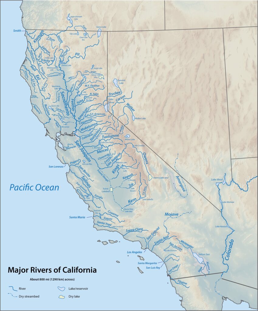
Here is a high resolution rivers map of California that shows all the major rivers, lakes in the state. Rivers are the backbone of any state because it’s the resource of water that is essential for the survival of human beings. Use a river map to understand the path of different rivers and lakes.
Following are some of the major rivers in California:
1) Sacramento River
Sacramento River is the longest river in California as you can see in the map. It flows through Sacramento County. It’s a major source of water for agriculture in the Central Valley.
2) San Joaquin River
San Joaquin River flows through counties like Fresno and San Joaquin.
3) Colorado River
Colorado River flows through counties like Imperial and Riverside.
Check out the map below to see how many rivers and lakes are there in California. Blue color lines in the map are rivers and lakes. This is a very good map to know more about the rivers and lakes in the state of California.
Map Source: https://en.wikipedia.org/wiki/List_of_rivers_of_California
California County is a great tool for residents, travellers, businesses, etc. The use of a map is not limited to navigation only, maps are used for research purposes as well. Businesses use a map when it comes to study the demographic of a particular region so they can plan their products and services accordingly. A map is one of the most versatile tool that can be used by people from different fields and industries.

