
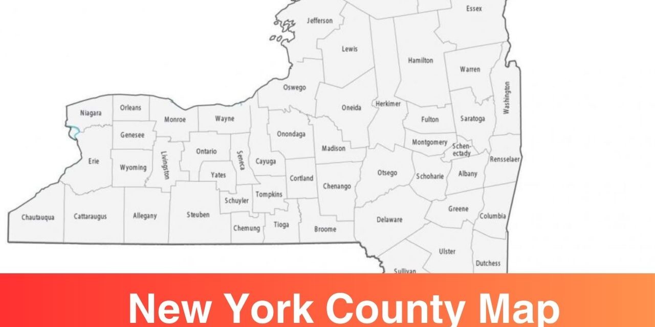
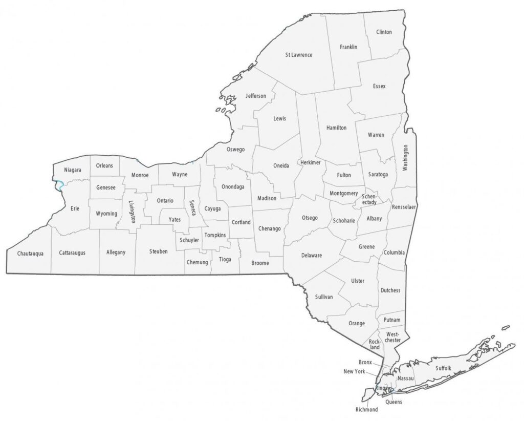
New York is a state in the United States. New York City is one of the most populous city in the United States and it’s a global hub for business, tech, media, and finance. To understand more about the New York, here we have shared New York County Map. There are 62 counties in New York. A printable map of New York is shared here with which you can understand the geographical area, names, location, and boundaries of each county.
New York Counties Map can be used for learning, educational, research and travel purposes. Check out the printable map templates on this page and download a suitable one for your use in a printable format.
New York Counties Map
A printable map is a valuable tool when it comes to understand the geography of any city or state. Through New York Counties Map, you get to know what’s the name of different counties, how far are they located to each other, which are the neighbouring counties, etc. Different type of printable maps are shared such as printable maps, blank map, maps with additional geographic features such as rivers, highways, lakes, transportation networks, etc.
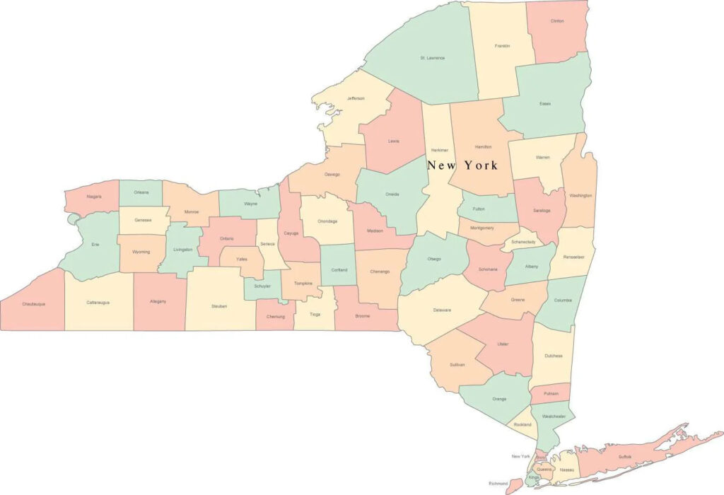
Counties in New York Map
New York is the economic center of the United States. It’s a global hub for business, technology, entertainment, media, etc due to which it attracts people from all over the world. People come to New York from different parts of the world either for business purposes or for travel purposes. Whatever the purpose is, you still need a map to understand different geographical routes.
How Many Counties are there in New York?
There are 62 counties in New York. You can check the name and geographic location of each county through printable maps shared in this page. New York counties are diverse, there are highly modernised urban areas and there are areas for agriculture, dairy farming, etc. The diversity of New York makes it unique and a suitable location for tourism, outdoor recreation, and economic development.
Some of the notable counties in New York are:
Manhattan (New York County): Manhattan is called the heart of the city. Popular landmarks are Empire State Building, Central Park, and Times Square.
Brooklyn (Kings County): Brooklyn is one of the most populous counties in the United States. Known for its diverse communites, vibrant art scenes, etc.
Queens (Queens County): Two major airports (JFK and LaGuardia) are there in New York. A lot of international visitors land at Queens and it’s quite famous for it’s international cuisine.
The Bronx (Bronx County): Popular places in the Bronx county are Yankee Stadium and the Bronx Zoo.
Staten Island (Richmond County): Staten Island is home to many of the beautiful beaches and parks. The major tourist attraction is the ferry views of the Statue of Liberty.
You can see the influence of both urban and rural in the culture of New York which makes it unique. New York City is very busy and it’s moving very fast, the city attracts a lot of people from all over the world. NYC is a hub for fashion, business, art, etc. If a busy and rapidly moving lifestyle is not for you then upstate New York offers a quieter and relaxed lifestyle where you can find close communities, small towns where people get together. Everything is there in New York from plain lands to mountains to beaches.
Whether urban or rural, each county contributes towards the growth of New York State. People in New York are very passionate and work driven, this is why it’s one of the largest economies in the world.
Summary
Printable Map of New York Counties is a guide or tool to understand the geography of different counties in New York. The use of printable maps is quite diverse i.e. it can be used by students, travellers, researchers, businesses, government, realtors, etc. If you are looking to know more about the counties of New York then do check out the printable maps templates shared in this page in a printable format.
New York’s Counties are a reflection of state’s incredible diversity. Each county has something different to offer. Get more insights about New York’s social, economic, and political landscape.