Georgia is one of the beautiful states in the United States, known for its natural beauty all over the world. Georgia is situated in the Southeastern region of the United States and it has borders with the Tennessee, North Carolina, South Carolina, and the Atlantic Ocean. If you want to know more of such interesting geographic facts and information about Georgia then we got you covered with Georgia County Map in a printable form.
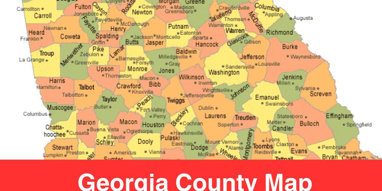
Just like any other state in the United States, Georgia is also divided into many counties. There are a total of 159 counties which is the second highest number after the Texas in the United States. Map of Georgia with counties is a perfect tool to understand or study the geographic diversity of this beautiful state.
In this guide, we’ll be covering the Georgia counties, cities, and rivers. Let’s get started!
Let’s Explore Georgia Counties
As mentioned, there are 159 counties in Georgia which is the second highest number of counties in a state. Texas has 254 counties which makes it the number one. Each county in Georgia has a separate administrative area of a state which means there is a local government that manages each county. Each county has it’s own significance and contribution in the development of Georgia.
Here are some interesting facts about counties in Georgia:
- Ware County is the largest county in Georgia in terms of area i.e. 903 square miles
- Clarke County is the smallest county in terms of area i.e. 121 square miles
- Fulton County is home of the state’s capital i.e. Atlanta. This county is the most Populous one in the Georgia.
The counties in Georgia are quite diverse and they have their role to play in the economic and cultural growth of Georgia. If you are interested to check out the names of each county in Georgia and understand their geographic positioning then check out the printable Georgia County Map in the next section.
Printable Map of Georgia with Counties
A printable map is one of the great tools that is often used by students, researchers, geographic enthusiasts, businesses etc. It’s one of the most versatile tool. Below you can see the printable version of Georgia County Map, the name of each county is there, and you can see the boundaries and border of each county. This is a great tool to learn the geographic positions of counties in Georgia.

More U.S, County Maps
- Map of California Counties
- Ohio County Map
- Texas County Map
- Florida County Map
- New York County Map
- North Carolina County Map
Georgia’s Lifelines: Exploring the Rivers That Shape the State
Rivers are one of the most important part of any state, it required for the survival of human life. There are many rivers and lakes that flows in Georgia, the printable rivers map of Georgia is shared in this section with which you can get to know more about the rivers. Make sure to Exploring the Rivers That Shape your State.
Following are some of the major rivers in Georgia:
Chattahoochee River
Chattahoochee River flows through many counties in Georgia such as Fulton, Cobb, and Muscogee. It’s a major source of water for drinking and recreation.
Savannah River
Savannah River flows through counties like Richmond (Augusta) and Chatham (Savannah). Its a great source for power generation and fishing.
Flint River
Flint Riverflows southward through counties like Dougherty (Albany). It supports agriculture and ecosystems.
For more information you can check out the printable map below. We humans are depended on rivers and lakes for our survival. We use rivers for water suppy, power supply, agriculture, and recreation, etc. We often don’t pay attention to the rivers, every person must have a knowledge about the rivers in his or her state. And please keep the rivers clean.
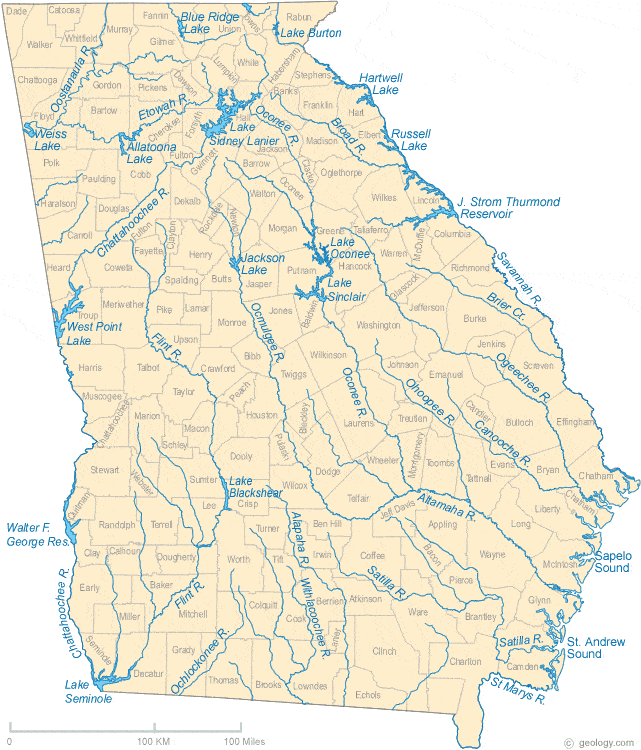
Map Source: https://geology.com/
How Georgia County Map is a Versatile Tool?
A county map is one of the most versatile tool and it can be used for a variety of purposes. Some of the uses of a county map are discusses here:
Travel Purposes:
The basic use of a map is for travel and navigation purposes. A map is used when it comes to navigate from one place to another. With Georgia County Map, you can easily navigate through different counties.
Business Research
Many companies and businesses use a county map to understand the demographic of different counties. This data helps companies and businesses to make products or services keeping the interests and demographics into consideration.
Explore History
A map is used by researches to explore history and find interesting facts.
Conclusion
Through the county map of Georgia, you get to know about the diversity of this state. Georgia has everything from plains to beaches to mountains. There are 159 counties in this state and each county has it’s own character and significance. If you are interested to explore the rivers, roads, mountains, and understand the geographic boundaries of each county in this state then do use a county map.

