Get World Map
Your Ultimate Destination for Maps – Explore, Learn, Create! We have a collection of high quality map templates, including world maps, blank maps, labeled maps, rivers maps, and more. Perfect for students, educators, travellers, and researchers.
Recently Added Maps
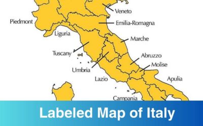
Labeled Map of Italy with Regions & Capitals
Here you can find out map of Italy labeled with states, capitals, and cities. If you are interested in studying the geography of Italy along with its states, capitals, and cities...
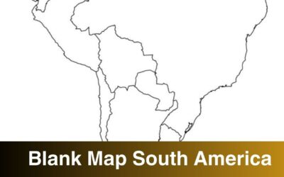
Blank Map of South America Printable PDF
Check out the blank map of South America here and download it for your use. This type of printable map is suitable for studying the geography of a continent. With the help of...
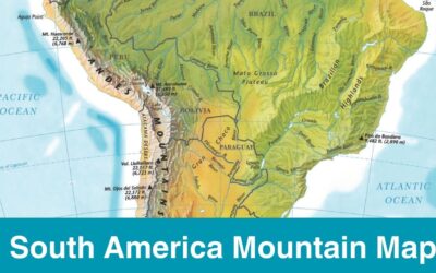
Map of South America Mountains Printable Labeled PDF
Map of South America Mountains is shared here in a printable format. If you are looking for the South America map with Mountains then simply download it from here and begin the...
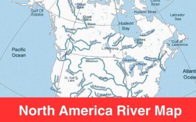
North America Rivers Map | Map of North America with Rivers
We have already shared South America rivers map and Africa river map and through this post we are updating you all with Map of North America Map. If you are looking to study the...
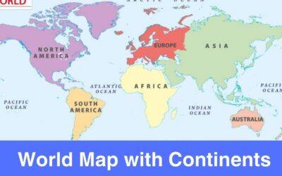
Printable World Map with Continents Labeled Blank Template
To begin with, there are seven continents in the world and they are Asia, Africa, Europe, South America, North America, Antarctica, Australia or Oceania. The entire world is...
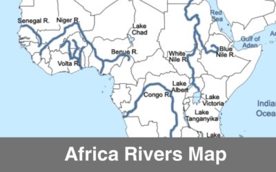
Map of Africa with Rivers & Lakes Printable PDF
Are you interested in knowing the geography of rivers in Africa? If yes then check out the Africa rivers map below and download it for your use. The longest river in the Africa...
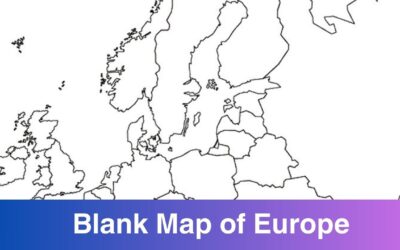
Printable Blank Map of Europe Countries – Outline, PDF
Europe is one of the continents, located entirely in the Northern Hemisphere and mostly in the Eastern Hemisphere. There are 44 countries in Europe today, according to the United...
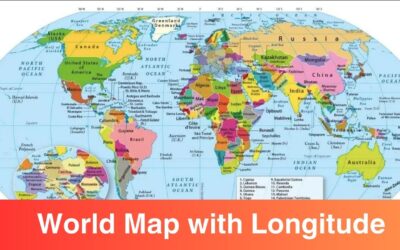
Printable Map of the World with Latitude and Longitude Lines
Check out the map of world here with Latitude and Longitude, you can download the world map here for free download in PDF format. A world map is of the important tools that comes...
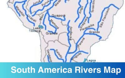
Map of Rivers in South America
Map of Rivers in South America: South America is the 4th largest continent in the world by land area. There is a lot to cover and learn when it comes to the geography of the...
United States County Map – State Wise
North Carolina County Map
Texas County Map
Georgia County Map with Cities
New York County Map
Map of Ohio Counties
Map of Michigan Counties
Florida County Map
California County Map with Cities
Florida County Map with Cities


What is a Map and Purpose of using it?
Through a map, you get to know the geography of a particular region or area. The use of map is there from hundreds of year, yes the maps has evolved with time but the purpose remains the same. Map is commonly used to navigate, understand, and analyze different places. With the help of a map, you can study geography from cities and countries to oceans and mountains. With the use of a map, you can understand various elements of geography such as political boundaries, borders, roads, population density, natural resources, etc.
Maps have been used for centuries and they have evolved with time. The world has evolved simple map drawings to digital maps. Geography is incomplete without maps, they are the essential tool to explore, plan, and study different places.
Here is why maps are used:
For Navigation:
The most common use of a map is to navigate from one place to another or to find routes. Through maps, people get to know the roads, landmarks, and direction. A map is most commonly used by people who are driving, hiking, etc.
For Research and Education:
Maps are the lens through which we all study geography. Maps has made the process of understanding demographics, climate, etc very easy. They are the center of geography. Researchers often use maps to find new places or conduct their research regarding medicines, etc.
Tourism and Travel:
Travellers or tourists often use maps to find out attractions, amenities, and plan their itineraries. A map is a must to have piece of paper specially for travellers.
Business and Market Analysis:
These days, a lot of businesses and companies are using maps to study the demographics, market trends, and logistics of different places or regions. This data is further used to plan products or services for a certain demographic.
What Type of Maps are Available?
Maps are used by people of all age groups and they are used in different industries, so it’s clear that there are different type of maps. In this section, we will briefly see what type of maps are available these days and what’s the purpose of their existence. Le’t study different map types:
1) Physical Maps
Physical maps are the most common ones which we often use to study about mountains, rivers, lakes, deserts, and plains. These type of maps are used in geographic classes. They are used to explore geography and study ecosystems. We do have a plenty of physical maps on this website as well, do check them out.
2) Political Maps
Want to study the boundaries and borders of different countries, states, or cities? Then you need a political map. This type of map highlight administrative regions, capitals, and major cities, these maps are suitable for understanding political divisions and governance.
3) Road Maps
Road maps are used for navigation purposes. If you are travelling by car, bike, or planning a road trip then road map is an essential map to have. With the advancement in technology, we have GPS today which is the digital version of road maps. Road maps are still used because it’s cool to use them while travelling.
4) Population Maps
Population Maps are used to understand the distribution of people across different regions. This map is used mostly at the government level where they need to do urban planning and resource allocation depending on the population of a region.
5) Historical Maps
These maps shows how the countries, cities, states were in the past. The geographical positions are shifting with time and through historical maps you can see how the geography of a particular region has changed over a period of time.
About Us
www.getworldmap.com is an information website that provides world map, country maps, county maps templates in an editable and printable format. A map is one of the most valuable tool that is commonly used for learning, education, research, market analysis, navigation, and travel purposes.
Understanding about a particular area geography or navigation through different counties or countries becomes easy when you have a good high resolution with you and this is the reason we have created this website i.e. to provide high resolution printable map templates for free download in a printable and digital format.
